The Viet Nam Meteorological and Hydrological Administration (VMHA) has consistently shared data from 33 surface meteorological stations, six upper-air stations, and 15 climate stations as part of its regular international reporting commitments to the World Meteorological Organization (WMO).
WMO has designated Viet Nam the Regional Forecast Support Center (RFSC Hanoi) for hazardous weather in Southeast Asia and the regional flash flood forecasting support center. VMHA provides hazardous weather, flash flood, and landslide warning bulletins to Southeast Asian countries. This has received positive feedback from international partners, particularly WMO and neighboring countries, who value Viet Nam's contributions to enhancing the quality of their forecasts.
These activities have gradually improved VMHA's capacity for hazardous weather forecasting in Viet Nam and the broader Southeast Asian region, enhancing Vietnam's international standing in disaster prevention and mitigation.

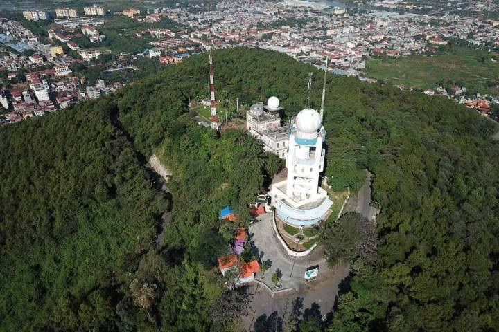
Phu Lien Weather Radar Station – Phu Lien Meteorological Station at Phu Lien Observatory Hill, Kien An, Hai Phong, recognized by the World Meteorological Organization for its over 100 years of observational history.
Viet Nam also proudly hosts three century-old meteorological and hydrological stations recognized by WMO: Phu Lien Meteorological Station (2019), Ha Noi Hydrological Station (2024), and Chau Doc Hydrological Station (2024). These stations meet WMO's criteria for historic recognition, including continuous data collection of at least one meteorological factor, consistent operation, adherence to WMO standards, and maintenance of comprehensive historical datasets. For over a century, these stations have provided critical data to support timely forecasting of dangerous weather events, such as storms and floods, helping to reduce disaster-related damage.
Additionally, through the WMO Global Atmosphere Watch program, Viet Nam has a global climate monitoring station in Pha Din under the Northern Mountainous Regional Hydro-Meteorological Station. Pha Din station provides timely and comprehensive foundational data to support international climate monitoring.
Beyond collaboration with WMO, VMHA has strengthened its partnership with the Intergovernmental Oceanographic Commission (IOC) via the Institute of Oceanography, sending sea level data from Quy Nhon and Vung Tau stations to support tsunami forecasting and early warning for the Asia-Pacific region. As part of its cooperation with the Mekong River Commission (MRC) via the Viet Nam Mekong River Commission, VMHA shares data from several hydrological stations in the lower Mekong basin. In cooperation with the China Meteorological Administration (CMA), VMHA exchanges technical support, data, hazardous weather information, and multi-hazard early warning capabilities. Both countries also consult during significant storms in the region.
Through bilateral partnerships and international cooperation, VMHA receives and shares essential meteorological and hydrological data to enhance forecasting domestically and internationally. These efforts support joint monitoring of meteorological and hydrological phenomena, significantly contributing to disaster prevention and response regionally and globally.